

LIVE UPDATES: Severe storms moving through NE Oklahoma, bringing rain and strong winds
News On 6 Chief Meteorologist Travis Meyer is tracking severe storms moving through northeastern Oklahoma.Wednesday, June 18th 2025, 12:29 am

News On 6 Chief Meteorologist Travis Meyer is tracking a severe storm moving through northeastern Oklahoma.
Several outages have been reported in Green Country.
Watches and Warnings
A severe thunderstorm warning has been issued for Craig, Mayes, Nowata, Osage, Rogers, Tulsa, Wagoner and Washington County until 1:15 a.m.
A severe thunderstorm warning has been issued for Creek, Muskogee, and Okmulgee County until 12:45 a.m.
A severe thunderstorm watch has been issued for Adair, Cherokee, Craig, Creek, Delaware, Hughes, Kay, Lincoln, McIntosh, Mayes, Muskogee, Noble, Nowata, Okfuskee, Okmulgee, Osage, Ottawa, Pawnee, Payne, Rogers, Tulsa and Wagoner County until 4 a.m.
Emergency Info: Outages Across Oklahoma:
Northeast Oklahoma has various power companies and electric cooperatives, many of which have overlapping areas of coverage. Below is a link to various outage maps.
- PSO Outage Map
- OG&E Outage Map
- VVEC Outage Map
- Indian Electric Cooperative (IEC) Outage Map
- Oklahoma Association of Electric Cooperatives Outage Map — (Note: Several Smaller Co-ops Included)
Follow News On 6 Meteorologists on Facebook
- Meteorologist Travis Meyer
- Meteorologist Stacia Knight
- Meteorologist Alan Crone
- Meteorologist Stephen Nehrenz
- Meteorologist Aaron Reeves
- Meteorologist Chloe Arroyo
Timeline
12:11 a.m.: Severe thunderstorm warning has been extended until 12:45 a.m. for areas east of Tulsa. Storms are moving at about 65 mph and have wind gusts up to 70 mph possible. These storms are moving east very quickly.
Related: Strong winds produce sideways rain from severe storm entering Jenks
11:52 p.m.: Here is another look at this line of storms that is all in severe thunderstorm warnings. The main threat is extremely strong winds.

11:34 p.m.: Severe thunderstorm warning has been issued until 12:15 a.m., and here is a storm track. Wind gusts up to 70 mph and quarter-sized hail is possible.

Storm tracker Dal was near Cleveland and observed a slight lowering of the storm.
11:21 p.m.: Here is a storm track for part of this line of storms headed east at about 65 mph.
")
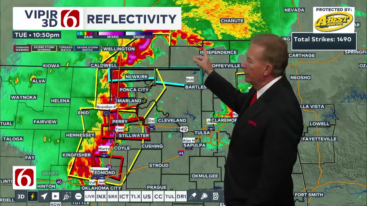
11:05 p.m.: This entire line of storms is in severe thunderstorm warnings with embedded tornado warnings. These storms are moving east at about 65 mph. Winds up to 70 mph and quarter-sized hail are possible.

10:45 p.m.: Multiple tornado warnings are active along a line of storms moving east at 70mph. A tornado warning has just been issued for Payne and Noble counties, in effect until 11:15 p.m.
10:10 p.m.: A severe thunderstorm warning has been extended for Nowata, Craig, Rogers, Mayes, Delaware, and Ottawa counties until 11 p.m. This storm is moving east at 60mph.
10 p.m.: There are TWO confirmed tornadoes and one tornado warning west of I-35, moving east. Numerous severe T-Storm warnings continue across the state that we're tracking.
9:55 p.m.: A severe thunderstorm warning has been extended for Nowata and Craig counties until 10:45 p.m. This is NOT a tornado warning, but it does have a tornado TAG on the warning, meaning there is the possibility for rotation to develop along the edge of the line near Nowata.
9:50 p.m.: The southern edge of the storm moving towards Tulsa County has weakened due to an outflow boundary moving quicker than the storm itself. Right now, the storm near Nowata is the strongest portion of the storm.
9:35 p.m.: A severe thunderstorm watch has now been issued for the counties shaded in blue until 4 a.m.
9:35 p.m.: HEAVY rain is moving through Bartlesville and surrounding towns right now. Expect flooding impacts and damaging wind and hail.
9:30 p.m.: The southern edge of the Osage County storm is moving south towards Tulsa County. This was once a destructive severe thunderstorm warning, but is now beginning to slightly weaken as it becomes outflow dominant. Still, prepare for a strong storm if you're in the Tulsa metro.
9:23 p.m.: Strong winds are moving along the leading edge of these storms, moving through all of Washington County. The southern end of this storm will track further south and eventually impact areas in northern Tulsa County.
9:10 p.m.: Large hail is showing up on radar on this storm as it moves into NE Osage County.
9:03 p.m.: A DESTRUCTIVE severe thunderstorm warning has been issued for eastern Osage County, moving SE near Wynona and Avant. This storm is producing 70+ mph wind gusts. There is a potential of trees falling and power outages with this storm.
9 p.m.: 70mph wind gusts have been recorded near Pawhuska so far.
8:50 p.m.: A severe thunderstorm is moving ESE towards Washington County, moving into Bartlesville and surrounding areas. This storm has produced 70mph wind gusts near Pawhuska.
8:46 p.m.: A severe thunderstorm warning has been extended for NE Osage County and northern Washington County until 9:30 p.m.
8:33 p.m.: The storm moving into Osage County is taking an ESE track. Here are a few of the estimated times of arrival.
8:20 p.m.: News On 6 storm trackers are getting positioned all across Green Country, and Bob is set up along the eastern edge of the storm moving into Osage County.
8:10 p.m.: A severe thunderstorm warning has been issued for far NW Osage County. This is likely the start of a stormy night for most of Green Country.
4:40 p.m.: A tornado watch is in place for the following counties until 10:00 p.m.

Katie Alexander
Katie Alexander joined News On 6 in August 2023 as a Web Content Producer. A multi-generation Oklahoman, Katie graduated from the University of Tulsa in 2023 with a bachelor's degree in Media Studies.

Get The Daily Update!
Be among the first to get breaking news, weather, and general news updates from News on 6 delivered right to your inbox!
More Like This

June 18th, 2025

June 8th, 2025


Top Headlines
June 18th, 2025


June 18th, 2025