

Tulsa Easter Weekend Weather: Severe storms, heavy rain and flood threat timeline HERE
Tulsa area braces for severe storms, flooding and cooler temperatures through Easter Sunday. The News On 6 Weather Team has a timeline.Saturday, April 19th 2025, 5:12 am

TULSA, Okla. -
All eyes will be on the Oklahoma skies this Easter weekend as severe storms will move in.
A powerful spring storm system is set to deliver rounds of rain, thunderstorms and potential severe weather across Oklahoma from Friday afternoon through Easter Sunday, with Tulsa and surrounding areas facing the full force of the impact.
Watches and Warnings:
- The National Weather Service has issued a Flash Flood Warning for Adair and Delaware counties until 7:45 a.m.
- A severe thunderstorm watch has been issued for Adair, Cherokee, Craig, Creek, Delaware, Haskell, McIntosh, Mayes, Muskogee, Okfuskee, Okmulgee, Ottawa, Pittsburg, Rogers, Sequoyah, Tulsa and Wagoner County until 3 a.m.
- A severe thunderstorm watch has been issued for Lincoln and Payne County until 4 a.m.
- A tornado watch has been issued for Hughes County until 4 a.m.
- A severe thunderstorm watch has been issued for Adair and Sequoyah County until 2:45 a.m.
>> Daily weather updates for Tulsa, Oklahoma, HERE.
Below is some information to remember and a full weather timeline for this weekend in Green Country.
🌩️ Oklahoma Storm Timeline: What to Know April 19–21
Oklahoma Severe Weather Key Takeaways:
- Severe Weather Threat Friday Night: A strong upper-level system arrived, bringing the potential for severe storms late Friday into Saturday, especially near the cold front.
- Heavy Rain and Severe Storms Saturday: Storms may bring damaging winds, hail, and localized flooding. Areas along and south of I-40 in Oklahoma will be most at risk, with temperatures ranging from the upper 60s to mid-70s.
- Unsettled Easter Morning: Some rain and thunder are possible early Sunday as the front lifts slightly. Conditions should clear by midday with highs in the upper 60s.
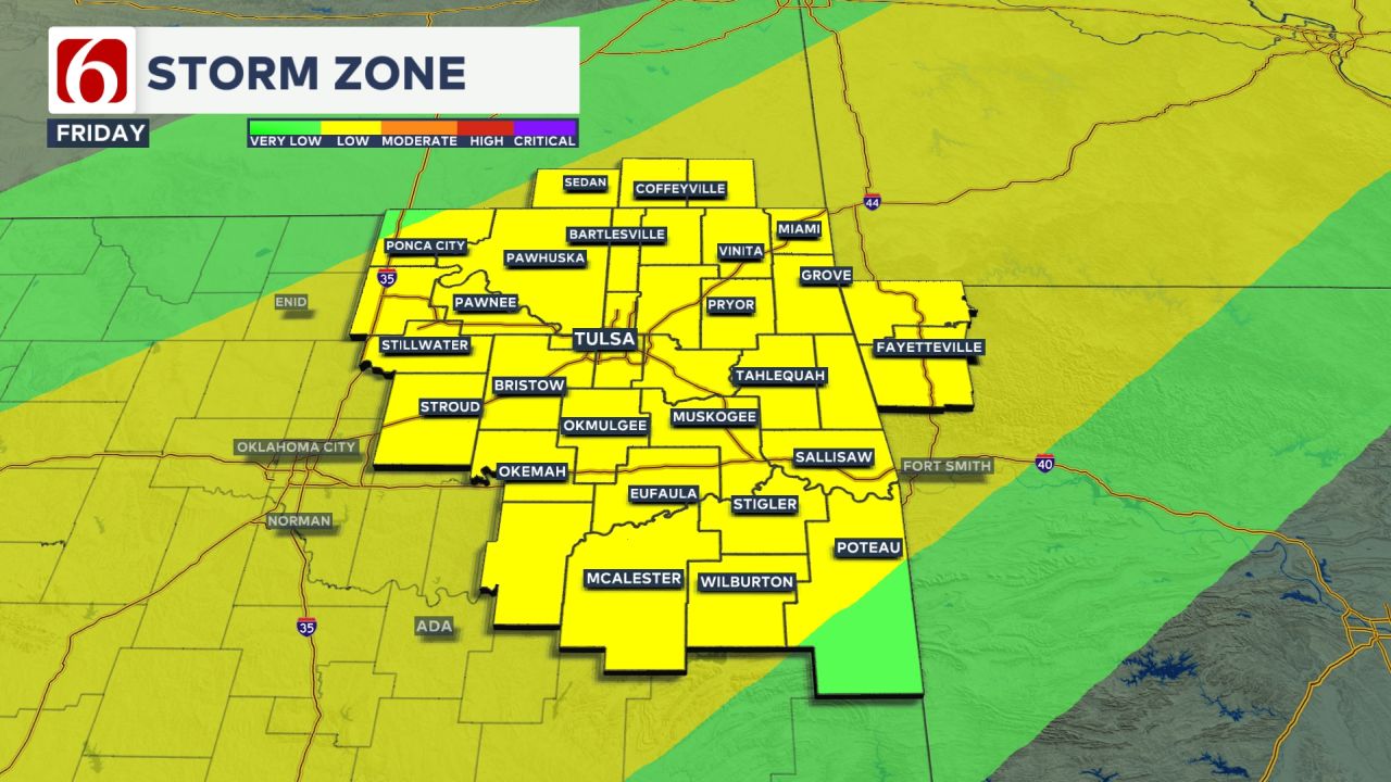
📅 Friday, April 18: Warm Temps, Cold Front & First Severe Threat
On Friday, a strong southwest upper-level flow from the Desert Southwest continued to intensify.
Several severe storms fired off, with one storm turning into a tornado after it moved into Arkansas.
The Storm Area in Oklahoma On Friday

⛈️ Saturday, April 19: Cooler, Wet, and Unsettled
- Morning: Storms continue into early morning, especially east of Tulsa.
- Daytime Highs:
- North of the front: Upper 50s to low 60s
- South of the front: Mid to upper 60s
- Winds: Gusty north winds will usher in cooler air behind the front.
- Rainfall: Persistent light-to-moderate rain likely through the day, with pockets of heavy rain possible.
- Severe Round #2?
- New storms may develop Saturday night, especially in southern Oklahoma
- Some could turn severe again by late evening into early Sunday morning
Saturday Severe Threats Include Heavy Rainfall
Some of the storms near and south of the front will be strong to severe with damaging winds and hail. Most locations will have a threat of heavy rain on Saturday.
The boundary is expected to move south of the I-40 corridor early Saturday morning before stalling, placing much of eastern Oklahoma in the zone for pockets of locally heavy rainfall through midday Saturday.
Locations north of the front, mostly along and north of I-40, will see highs in the upper 60s, while areas south of I-40 will experience temperatures in the mid-70s on Saturday.
🌧️ Sunday, April 20 (Easter): Stormy Start, Calmer Finish
- Morning: Rain and some embedded storms continue into early Easter morning
- By Late Morning (9 a.m. – Noon):
- Storms should exit eastern Oklahoma, including Tulsa
- Conditions improve rapidly midday into afternoon
- Afternoon Highs: Mid 60s with drying conditions and a return of sunshine for some areas.
Easter Sunday: Continued Storm Chances
As the upper-level wave merges and progresses across the middle of the country, the front could briefly lift north as a surface low-pressure system develops along its boundary early Sunday morning.
This may keep some rain and thunder near the region early Sunday before moving east, out of the area quickly Sunday morning. This portion of the forecast may still undergo additional changes.
Easter Sunday morning temperatures will generally be in the mid-50s with highs reaching the upper 60s.
Need-to-know severe Oklahoma weather prep:
🔗Severe weather safety: what you need to know to prepare
🔗Tornado Watch vs. Tornado Warning: what they mean and what to do
🔗Severe weather safety: what to do before, during, and after a storm
🔗Why registering your storm shelter in Oklahoma could save your life


Alan Crone
An integral part of the News On 6 Weather Team since 2006, Alan Crone keeps Oklahomans safe and informed about morning weather each weekday on Six in the Morning. He’s always keeping an eye on the sky for both severe weather and just weather that’s going to make your day a bit more interesting.

Get The Daily Update!
Be among the first to get breaking news, weather, and general news updates from News on 6 delivered right to your inbox!
More Like This

April 19th, 2025
April 16th, 2025

August 8th, 2023

July 4th, 2023
Top Headlines

September 4th, 2025

September 4th, 2025

September 4th, 2025

September 4th, 2025