

Severe storms likely in Oklahoma this Easter Weekend: Here are some Key Updates & Weather Timeline
Severe storms are in the forecast for Oklahoma over Easter Weekend, with high winds, heavy rain, and possible hail, particularly on Saturday.Wednesday, April 16th 2025, 4:05 pm

All eyes will be on the Oklahoma skies this Easter weekend as a chance for severe storms moves in Friday night.
The first signs of rough weather start pre-dawn on Thursday to the north along the Oklahoma-Kansas state line. Most of that will move out by the morning.
Below is some info to remember and a full weather timeline of what you can expect this weekend in North and East Oklahoma.
Oklahoma Severe Weather Key Takeaways:
- Strong Winds Thursday: Expect south winds between 20–40 mph with a likely Wind Advisory. Highs will reach the mid-80s with mostly sunny skies.
- Severe Weather Threat Increases Friday Night: A strong upper-level system arrives, bringing the potential for severe storms late Friday into Saturday, especially near the cold front.
- Heavy Rain and Severe Storms Saturday: Storms may bring damaging winds, hail, and localized flooding. Areas along and south of I-40 in Oklahoma will be most at risk, with temperatures ranging from the upper 60s to mid-70s.
- Unsettled Easter Morning: Some rain and thunder are possible early Sunday as the front lifts slightly. Conditions should clear by midday with highs in the upper 60s.
Oklahoma's Severe Weather Timeline Thursday-Sunday: April 17-20
On Thursday, strong south winds will increase to speeds between 20 and 40 mph as the warm front continues lifting northward.
A wind advisory is more than likely going to be issued for most of the area on Thursday due to these strong winds.
Morning temperatures will begin in the lower 60s, with daytime highs reaching the mid-80s. Mostly sunny skies are expected throughout the day.
Wind Timeline

A layer of warm air aloft, known as the CAP, should prevent thunderstorms from developing across most of the region. Storms are likely to develop north of the state, across part of eastern Kansas into Missouri and Iowa.
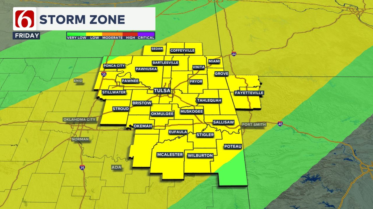
Increasing Severe Weather Threats Friday into Saturday
By Friday, a strong southwest upper-level flow from the Desert Southwest will continue to intensify.
A powerful upper-level wave moving down the Rockies is expected to merge with the Southern Stream, bringing additional upper air support for thunderstorms late Friday night into early Saturday.
Current data indicates the front will move into northern Oklahoma Friday afternoon, then shift slightly south of the metro late Friday night, triggering more frequent thunderstorms.
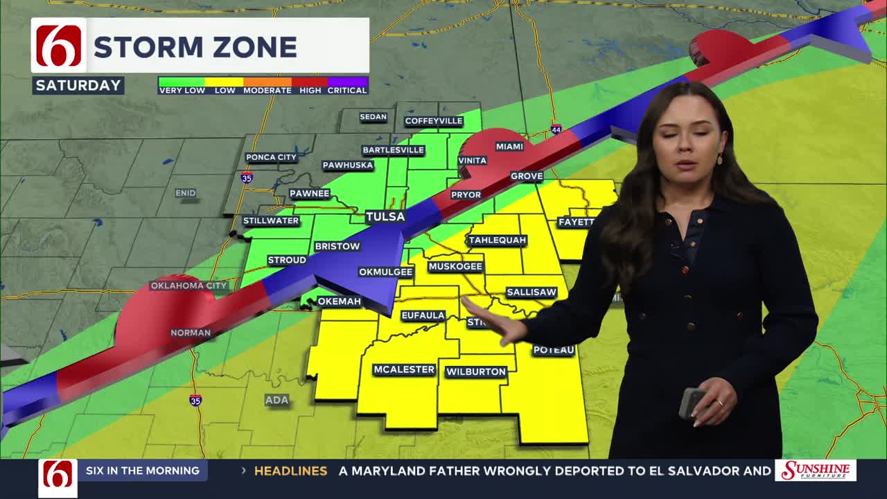
The Storm Area in Oklahoma On Friday
The position of the cold front Friday evening will be key in determining the extent of heavy rainfall and severe weather threats through the weekend.
Friday afternoon, temperatures will start in the upper 60s, with daytime highs in the lower to mid-80s before the front nears the area by the evening hours.
Saturday Severe Threats Include Heavy Rainfall
Some of the storms near and south of the front will be strong to severe with damaging winds and hail. Most locations will have a threat of heavy rain on Saturday.
The boundary is expected to move south of the I-40 corridor early Saturday morning before stalling, placing much of eastern Oklahoma in the zone for pockets of locally heavy rainfall through midday Saturday.
Locations north of the front, mostly along and north of I-40, will see highs in the upper 60s, while areas south of I-40 will experience temperatures in the mid-70s on Saturday.
Easter Sunday: Continued Storm Chances
As the upper-level wave merges and progresses across the middle of the country, the front could briefly lift north as a surface low-pressure system develops along its boundary early Sunday morning.
This may keep some rain and thunder near the region early Sunday before moving east, out of the area quickly Sunday morning. This portion of the forecast may still undergo additional changes.
Easter Sunday morning temperatures will generally be in the mid-50s with highs reaching the upper 60s.
Need-to-know severe Oklahoma weather prep:
🔗Severe weather safety: what you need to know to prepare
🔗Tornado Watch vs. Tornado Warning: what they mean and what to do
🔗Severe weather safety: what to do before, during, and after a storm
🔗Why registering your storm shelter in Oklahoma could save your life


Stephen Nehrenz
Stephen Nehrenz joined the News On 6 Weather Team in 2015 and can be seen weekday mornings on Six in the Morning where he tracks your morning commute and Tulsa’s never ending road construction. He can also be seen on weekdays during the News On 6 at Noon.

Alan Crone
An integral part of the News On 6 Weather Team since 2006, Alan Crone keeps Oklahomans safe and informed about morning weather each weekday on Six in the Morning. He’s always keeping an eye on the sky for both severe weather and just weather that’s going to make your day a bit more interesting.

Get The Daily Update!
Be among the first to get breaking news, weather, and general news updates from News on 6 delivered right to your inbox!
More Like This
April 16th, 2025

August 8th, 2023

July 4th, 2023

May 8th, 2023
Top Headlines

September 4th, 2025

September 4th, 2025

September 4th, 2025

September 4th, 2025