Tulsa weather Labor Day weekend: Below-normal temperatures hang on in Green Country With Rain Chances
Oklahoma’s weather remains very pleasant through Labor Day, though a few scattered showers are possible in parts of the state. A stronger cold front arriving mid to late next week could bring scattered storms and a noticeable drop in temperatures into early September.Friday, August 29th 2025, 1:12 pm
TULSA, Okla. -
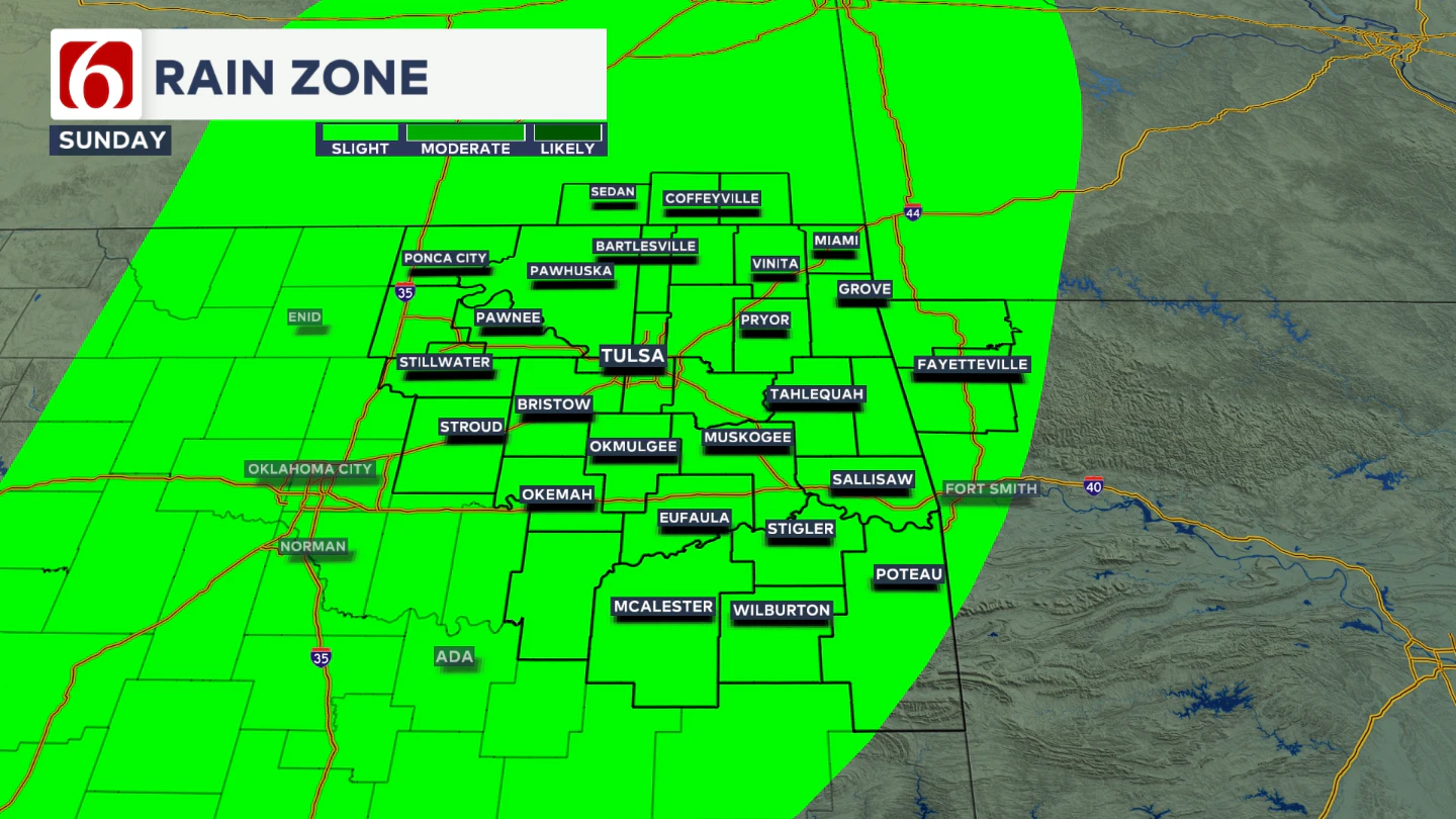
Will Sunday Bring Any Rain?
Some of us could see a few showers on Sunday as a weak upper level wave brushes the area.
Most locations, including the Tulsa metro, will have this slight chance for a few showers on Sunday. Most of this activity should stay light. But we could see a downpour or rumble of thunder in a couple of spots.

Temperatures stay mild and seasonally pleasant, with Sunday morning lows in the lower to mid-60s and afternoon highs reaching the upper 70s. Rain chances around Tulsa are about 30% to 40%.
What Can We Expect for Labor Day?
Labor Day continues the trend of pleasant weather. Expect partly sunny skies with morning lows in the mid-60s and afternoon highs in the low to mid-80s. A weak disturbance nearby could bring an early morning shower or storm to a few areas.

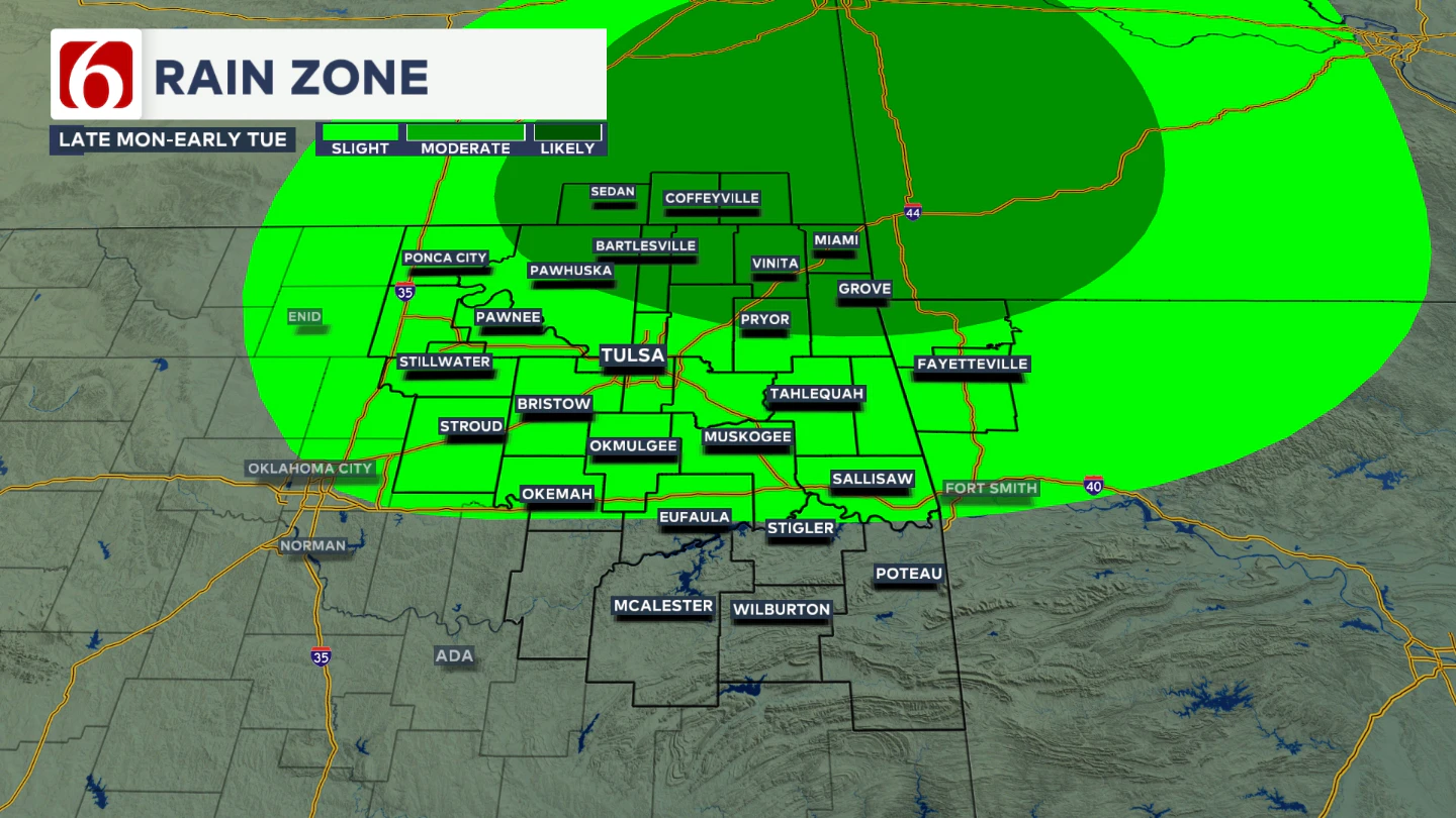
Late Monday night into early Tuesday morning, another stronger disturbance will move across the central plains and into northeastern Oklahoma early Tuesday morning. Some showers or storms will be possible with this disturbance during this period.
When Does the Next Stronger Front Arrive?
The next noticeable pattern shift arrives in the middle to late part of next week. A weak boundary will likely move through on Tuesday morning with the above-mentioned disturbance, but a stronger cold front is expected Wednesday night into Thursday.
That system could bring a round of scattered showers and thunderstorms along with cooler air. Ahead of the front, expect highs in the mid-80s with morning lows in the 60s.
Once it passes, another stretch of below-normal temperatures looks likely as we close out the week and head into the first weekend of September. Thursday morning lows should drop into the mid to upper 50s for most locations, with Thursday afternoon highs in the mid 70s.
How Long Will the Cooler Pattern Stick Around?
Forecast trends suggest that cooler-than-average temperatures may linger into next weekend. Highs could dip into the 70s, with some northern Oklahoma locations starting the day in the 50s.
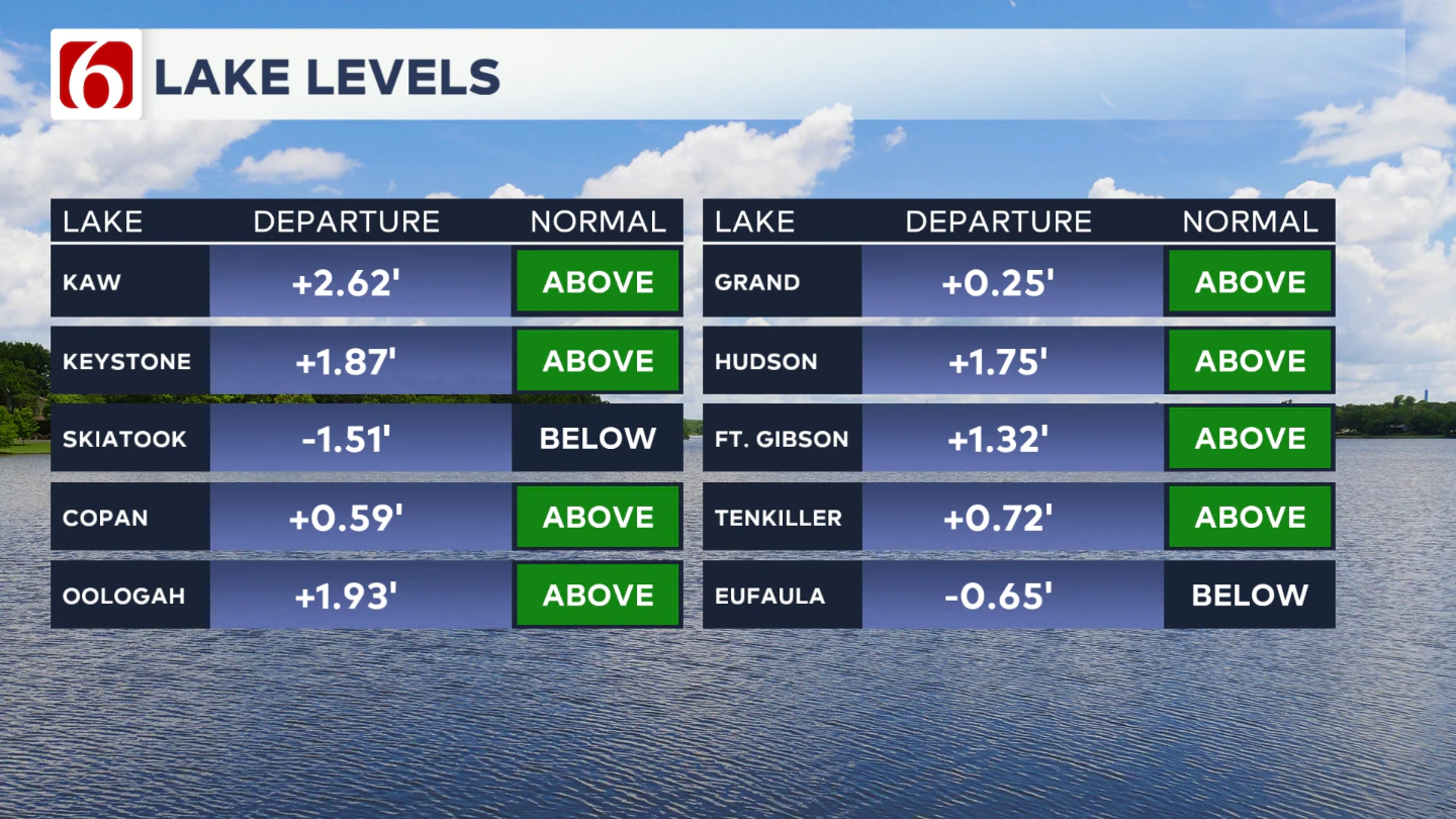
Lake Levels
If you're making some lake recreation plans, here's an update on our area lake levels.

The Morning Weather Podcast:
The daily morning weather podcast briefing will remain on hold indefinitely due to ongoing internal workflow issues.
We're working to resolve these challenges as soon as possible and appreciate your patience. We apologize for the inconvenience and hope to be back soon. Thank you for your understanding.
Hot weather safety:
🔗 Oklahoma heat safety tips: How to spot and prevent heat illness
🔗 Top summer safety tips every family needs to know
🔗 'It can happen to anybody': First responders warn of hot car deaths
Need-to-know severe Oklahoma weather prep:
🔗Severe weather safety: what you need to know to prepare
🔗Tornado Watch vs. Tornado Warning: what they mean and what to do
🔗Severe weather safety: what to do before, during, and after a storm
🔗Why registering your storm shelter in Oklahoma could save your life
🔗Floodwater kills more Oklahomans than tornadoes in the last decade, here's why
🔗'Turn around, don't drown': Flood safety tips for Oklahomans
🔗5 things to know: How Oklahomans can get federal money to install storm shelters
🔗Breaking down the SoonerSafe Rebate Program: Do I qualify for a storm shelter?
Watch us on YouTube
Follow NewsOn6 on X/Twitter for automated severe weather alert posts: @NewsOn6
Emergency Info: Outages Across Oklahoma:
Northeast Oklahoma has various power companies and electric cooperatives, many of which have overlapping areas of coverage. Below is a link to various outage maps.
- PSO Outage Map
- OG&E Outage Map
- VVEC Outage Map
- Indian Electric Cooperative (IEC) Outage Map
- Oklahoma Association of Electric Cooperatives Outage Map — (Note: Several Smaller Co-ops Included)
Follow News On 6 Meteorologists on Facebook
More Like This
August 29th, 2025
August 30th, 2025
August 30th, 2025
Top Headlines
August 30th, 2025
August 30th, 2025
August 30th, 2025


