Weather Blog: Active Weather Remains This Weekend
Oklahoma Weather Forecast: Bookmark this page and refresh it often for the latest forecast and daily updates.Thursday, October 31st 2024, 6:33 am
TULSA, Okla. -
After severe thunderstorms and a few tornado warnings last night, some damage was reported in the Fairland, OK region, and also near Prairie Grove, Arkansas. Some additional damage reports may arrive later this morning. No injuries have been reported.
🎃 What is the Halloween forecast? 🎃
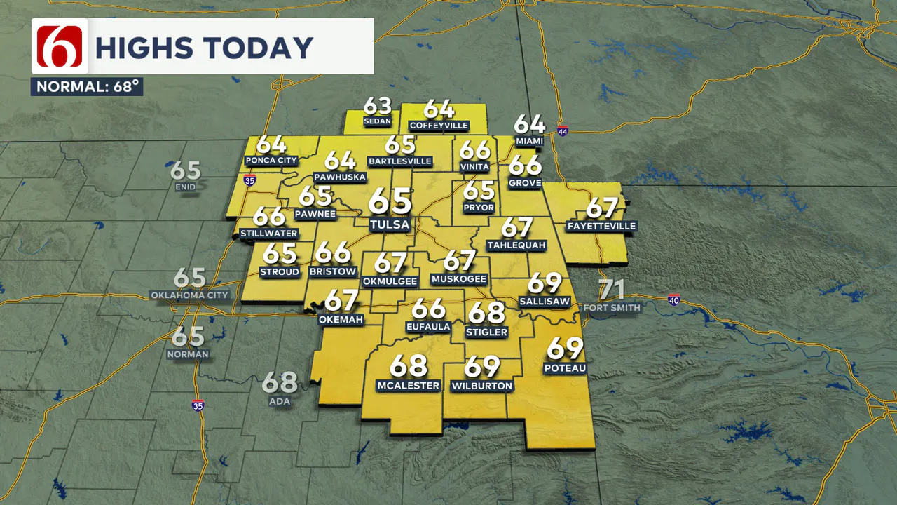
A cold front swept through southeastern Oklahoma earlier this morning taking the showers and storms out of the region. The northerly winds will continue throughout today and into the majority of tomorrow, bringing pleasant yet cooler weather conditions to northern Oklahoma and continuing through tonight.
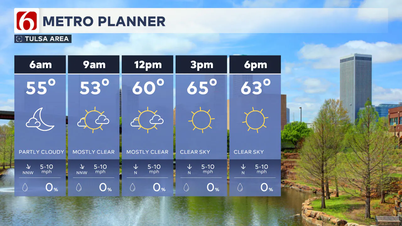
This morning's cloud cover will give way to abundant sunshine from midday into the afternoon with north winds around the 10 to 15 mph range. Temperatures will start in the 50s this morning and move into the lower mid-60s by the afternoon.
For those planning to go trick-or-treating during prime-time hours, expect the lower 60s to the mid-50s as the evening progresses with light north winds and a clear sky.
What is Friday's forecast?
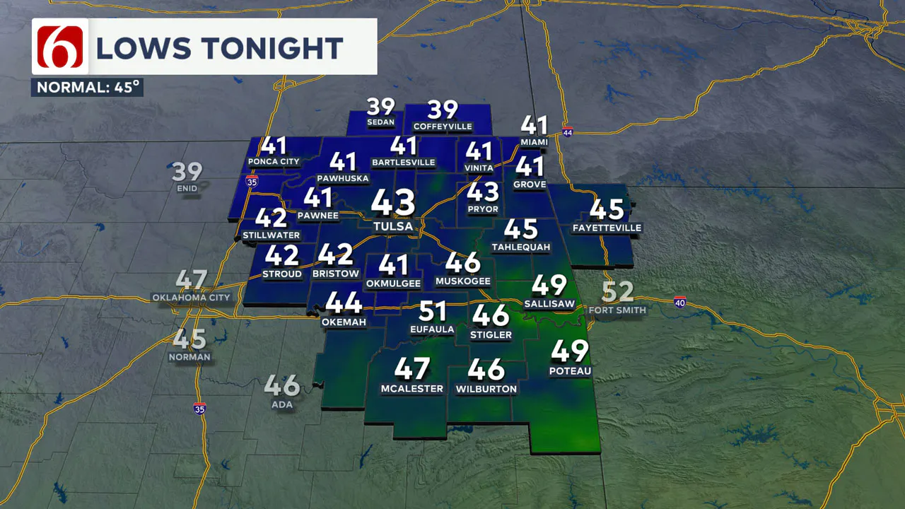
The combination of dry air, clear skies, and light winds will lead to a chilly start on Friday morning. Temperatures will start in the lower 40s in the Tulsa Metro area, with some valley regions dropping into the upper 30s.
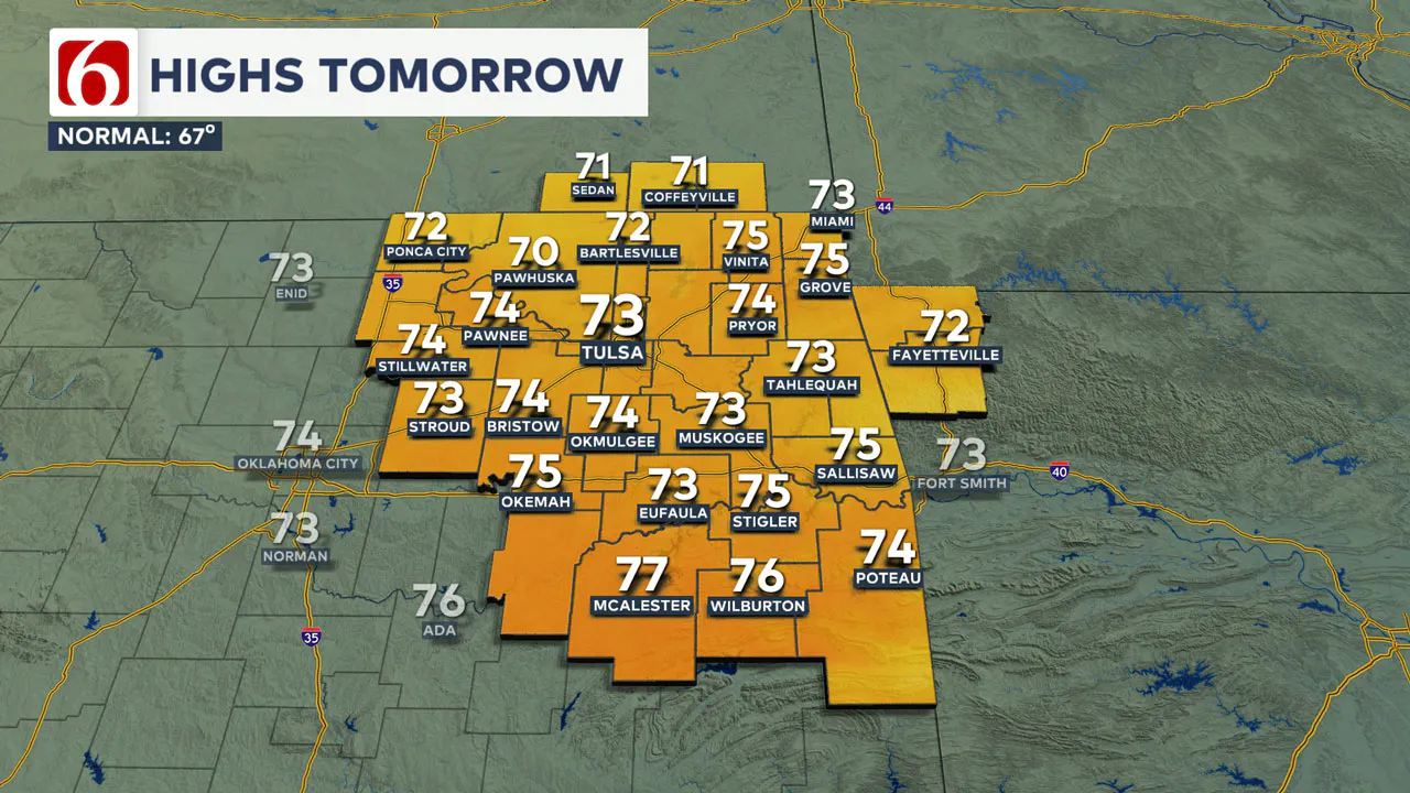
Friday afternoon highs will be mostly in the lower 70s, with the southeast wind at 10 to 15 mph.
Friday night football should start in the lower to mid-60s and finish also in the lower-60s with increasing clouds. There will be a slight chance for a few showers nearing northern OK late Friday night, but higher chances will arrive Saturday and continue Sunday into part of Monday.
The weekend forecast:
The upcoming series of upper-level systems will begin to influence the area by late Friday night, bringing more showers and storms throughout the weekend. As the weekend progresses and low-level moisture intensifies across the region, we can expect showers and storms to become efficient rainfall producers, potentially leading to localized areas of heavy downpours. Severe weather threats on Saturday should be relatively low.
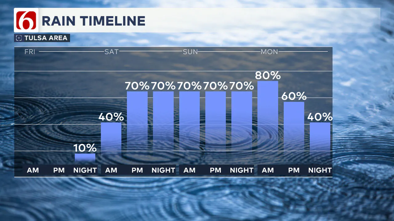
The likelihood of more potent storms increases slightly for Sunday and Monday, coinciding with the approach of a more robust upper-level trough towards the state. The exact timing of these disturbances over the weekend and into the early part of next week may change, but I’ve kept likely categories from Saturday afternoon through Monday.
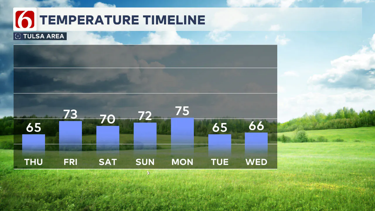
This weekend, anticipate morning lows mostly in the upper 50s to lower 60s with daytime highs reaching the upper 60s and lower 70s.
Next week's forecast:
According to a consensus of data, a cold front is expected to pass through the area by Monday evening, taking most of the storms out of the region.
The main upper-level trough may not clear the area Tuesday, but we should experience a dry slot Tuesday morning, making the way for clear and cool conditions for Election Day.
What are the major traffic projects around Tulsa this week?
The Oklahoma Department of Transportation (ODOT) and Oklahoma Turnpike Authority (OTA) provide daily details on several traffic advisories for the Tulsa area and surrounding regions.
To start October, here are some of the significant traffic advisories. For more information, see our detailed list.
I-244 Pavement Rehabilitation
- Ongoing pavement work between I-44 and the Arkansas River bridge, with lane and ramp closures lasting through spring 2025.
US-75 Bridge Rehabilitation
- Lane closures at 7th St. and off-ramp closures to 7th St. through fall 2024 for bridge rehabilitation.
US-412 Bridge Rehabilitation
- US-412 narrowed to two lanes at 81st W. Ave. in Sand Springs through February 2025.
Emergency Info: Outages Across Oklahoma:
Northeast Oklahoma has various power companies and electric cooperatives, many of which have overlapping areas of coverage. Below is a link to various outage maps.
Indian Electric Cooperative (IEC) Outage Map
Oklahoma Association of Electric Cooperatives Outage Map — (Note Several Smaller Co-ops Included)
The Alan Crone morning weather podcast link from Spotify:
https://open.spotify.com/show/0dCHRWMFjs4fEPKLqTLjvy
The Alan Crone morning weather podcast link from Apple:
Follow the News On 6 Meteorologists on Facebook!

More Like This
October 31st, 2024
October 31st, 2024
October 31st, 2024
October 31st, 2024
Top Headlines
October 31st, 2024
October 31st, 2024
October 31st, 2024


