A look at the meteorology behind Hurricane Katrina 20 years later
A look back at the meteorology of Hurricane Katrina shows how a tropical depression in August 2005 rapidly intensified into one of the deadliest and costliest storms in U.S. history, making three landfalls and devastating the Gulf Coast.Friday, August 29th 2025, 10:51 am
NEW ORLEANS -
What started as Tropical Depression Twelve on Aug. 23, 2005, over the Greater Antilles would soon become one of the deadliest hurricanes on record to hit the United States.
Traveling through southeastern Florida, up into the Gulf Coast and eventually disintegrating over the Ohio Valley, nothing could prepare those in Katrina's path for what they are still reeling from to this day, 20 years later.
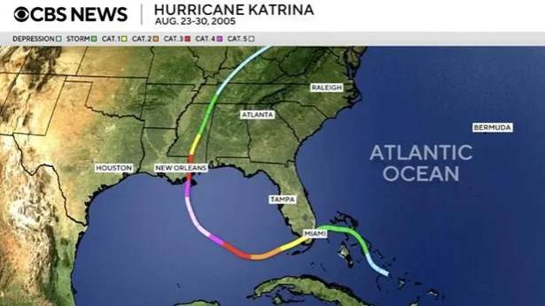 (A look at the path of Hurricane Katrina. / CBS News)
How Hurricane Katrina formed
A tropical wave moved off the coast of Africa into the Atlantic Ocean on Aug. 11, 2005, on a westward path. As it crossed the Central Atlantic and eventually reached the Leeward Islands, on Aug. 19 it combined with the remnants of what was once Tropical Depression Ten.
The tropical wave dominated the interaction and began to form a large area of organized thunderstorms over parts of Puerto Rico.
At 2 p.m. ET on Aug. 23, Tropical Depression Twelve formed as a distinct center of circulation and was strengthening about 175 nautical miles southeast of Nassau, Bahamas.
As hurricane hunters investigated the storm system, Katrina received its name when it strengthened into a tropical storm with maximum sustained winds of 40 mph on Aug. 24, 2005, at 8 a.m. ET, about 65 nautical miles east-southeast of Nassau.
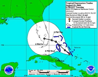 The path of Hurricane Katrina before it made its first landfall in the U.S. on Aug. 25, 2025. NOAA
Tropical Storm Katrina continued on a west-northwestward path toward Florida, as residents had minimal time to prepare. Katrina became a hurricane at 5 p.m. ET on Aug. 25, 2005, with maximum sustained winds of 75 mph. A Category 1 hurricane has a sustained wind speed of 74-95 mph.
Katrina became a hurricane less than 2 hours before it made landfall in Southern Florida.
Katrina made landfall in the U.S. three times
Also known as "the forgotten landfall," the first of three landfalls was made on Aug. 25, 2005, at 6:30 p.m. ET in Hollywood, Florida, as a Category 1 hurricane with maximum sustained winds of 80 mph. It spent about 6 hours overnight traveling through the state of Florida, mostly impacting the Florida Everglades. As it had no fuel source over land, it quickly weakened back down to tropical storm status overnight with 69 mph winds.
As Katrina continued on its westward path and eventually reached the Gulf, it quickly regained strength. It became a Category 1 hurricane once again at 2 a.m. ET on Aug. 26, 2005, over the Eastern Gulf. Not only did it start to strengthen, but it also underwent rapid intensification twice in the next 48 hours.
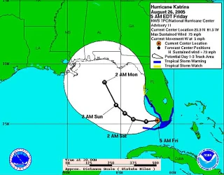 The path Hurricane Katrina took as it made its second landfall in Louisiana on Aug. 29, 2025. NOAA
Rapid intensification occurs when the maximum sustained winds of a tropical cyclone increase by at least 35 mph in a 24-hour period. Katrina jumped from 75 mph to 109 mph from Aug. 26 to the morning of Aug. 27. It underwent rapid intensification a second time, from Aug. 27 to Aug. 28, when it jumped from 115 mph to 167 mph.
Katrina reached its peak intensity with maximum sustained winds of 173 mph at 2 p.m. ET on Aug. 28, about 170 nautical miles southeast of the mouth of the Mississippi River.
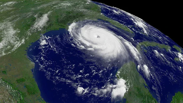 In this satellite image from the NOAA, Hurricane Katrina is seen in the Gulf of Mexico on Aug. 28, 2005. NOAA via Getty Images
Katrina experienced an Eyewall Replacement Cycle
Katrina was so intense in strength that it also experienced what is known as an Eyewall Replacement Cycle. This occurs when the eyewall, which is where the strongest winds of a tropical system are, reaches its maximum capacity, so much so that another eyewall forms on the outside of it. This cuts off fuel to the original eyewall and eventually diminishes it, resulting in the system weakening, as well. This occurred with Katrina on Aug. 28, leading to the rapid weakening prior to its second landfall on the Gulf Coast.
That second landfall took place on Aug. 29, 2005, at 7:10 a.m. ET in Buras, Louisiana, as a Category 3 hurricane with maximum sustained winds of 127 mph. It quickly made a technical third landfall on the Louisiana-Mississippi border at 10:45 a.m. ET, as a slightly weaker Category 3 hurricane with maximum sustained winds of 121 mph.
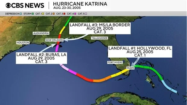 The three landfalls made by Hurricane Katrina. August 2005. CBS News
If a storm is a Category 3, 4 or 5, it is deemed a "major" hurricane due to the potential for "significant loss of life and damage," the National Hurricane Center says.
As expected, the storm lost its fuel from the warm waters of the Gulf as it moved over land. Katrina rapidly weakened to a Category 1 hurricane by 2 p.m. ET and a tropical storm only 6 hours later, at midnight on Aug. 30, 2005. It became a tropical depression over the Tennessee Valley by 8 a.m. ET on Aug. 30, but fully transitioned into a remnant low-pressure system by 8 p.m. ET that day.
Some facts and figures:
- Numerous observations of high storm surge were investigated by the Federal Emergency Management Agency, which determined that upwards of 24-to 28-foot storm surge was observed along the Mississippi coast.
- Storm surge was also observed to cross over Interstate 10 in several locations, with the highest east of Katrina's eye path.
- Even after the initial threat of Katrina had passed, the intensity of the storm surge put a strain on the New Orleans levee system. Levees are either manmade or natural embankments that help control the flow of water to protect land and communities. Storm surge overtopped and broke through levees and floodwalls, which caused excessive flooding in the New Orleans area.
- About 80% of New Orleans flooded, with some depths reaching up to 20 feet within the first 24 hours of Katrina's landfall.
- Katrina also produced a total of 43 tornadoes in the Florida Keys, Georgia, Alabama and Mississippi.
- 1,392 total fatalities were attributable to Katrina, according to a 2023 report from the National Hurricane Center. And according to the hurricane center, Louisiana reported that people over the age of 60 made up the majority of Katrina deaths in that state.
- Katrina stands as the third deadliest hurricane in the mainland U.S. since 1900, according to the hurricane center.
- Katrina contributed to about $125 billion in damage in 2005, according to the hurricane center, the costliest in U.S. history. Adjusting for inflation, that would be about $186.3 billion in 2022 dollars.
- The highest rainfall reports recorded from Katrina were up to 14.04 inches at Homestead Air Force Base in Florida.
- On Aug. 28, 2005, at 2 p.m. ET, Katrina's measured barometric pressure fell to 902 millibars, which was the fourth-lowest on record in the Atlantic Ocean. However, it has since dropped to sixth-lowest, behind Hurricane Rita and Hurricane Wilma, both of which occurred later in 2005.
- When Katrina made landfall in Buras, Louisiana, the measured pressure was at 920 millibars, which is the lowest on record in the Atlantic Ocean for a hurricane at an intensity of 127 mph.
- The 920 millibars at the Buras landfall is also the third-lowest on record for storms that made landfall in the U.S.
- The strongest sustained winds measured at a fixed location on land from Katrina were at 4:20 a.m. ET on Aug. 29, 2005, at 88 mph.
More Like This
August 29th, 2025
September 17th, 2025
September 17th, 2025
Top Headlines
September 17th, 2025
September 17th, 2025
September 17th, 2025


