Hurricane Erin likely to bring 'life-threatening surf and rip currents' to East Coast
Category 4 Hurricane Erin surges in Atlantic—National Hurricane Center warns of dangerous surf and rip currents on U.S. East Coast.Monday, August 18th 2025, 6:48 am
Hurricane Erin is likely to bring "life-threatening surf and rip currents" across the U.S. East Coast this week, the National Hurricane Center in Miami said early Monday.
Erin, the first Atlantic hurricane of 2025, restrengthened back into a Category 4 storm Sunday night as it churned over the Atlantic Ocean north of the Caribbean. It exploded to a Category 5 on Saturday before weakening to a Category 3 early Sunday morning, then regaining strength again later in the day.
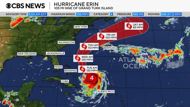
As of 5 a.m. EDT Monday, Erin had maximum sustained winds of 130 mph. The storm's center was about 105 miles north-northeast of Grand Turk Island and about 915 miles south-southeast of Cape Hatteras, North Carolina. It was moving northwest at 13 mph.
A Category 4 hurricane is defined as having maximum sustained winds from 130-156 mph and is considered a major storm, capable of causing catastrophic damage.
Maps show Hurricane Erin's forecast path
Erin is a large storm that's expected to remain powerful for the next several days, forecasters said. It is not expected to make landfall in the U.S.
 Map shows the projected path of Hurricane Erin as of Aug. 18, 2025. - CBS News
"The core of Erin is expected to pass to the east of the southeastern Bahamas today and move between Bermuda and the east coast of the United States by the middle of the week," the hurricane center said Monday. "Some additional strengthening is expected today. Even though some weakening is forecast beginning tonight, Erin will remain a large and dangerous major hurricane through the middle of this week."
Forecasters said Erin's hurricane-force winds — 74 mph or higher — extend outward up to 80 miles from the center, and tropical-storm-force winds extend up to 230 miles.
Tropical storm warnings were in effect for Turks and Caicos and the southeast Bahamas, the hurricane center said. The Bahamas government issued a tropical storm watch for the central Bahamas. A tropical storm warning means tropical storm conditions are expected somewhere within the warning area, while a watch means they are possible.
On the U.S. Virgin Islands, officials with the National Park Service announced that sites on the island of St. Croix would be closed starting late Friday afternoon until after the storm passes.
Erin's path continued to curve northward, with the center of the hurricane passing just to the north of the northern Leeward Islands and Puerto Rico. The northern Leewards stretch from the Virgin Islands to Guadeloupe and include St. Martin, St. Barts and other islands.
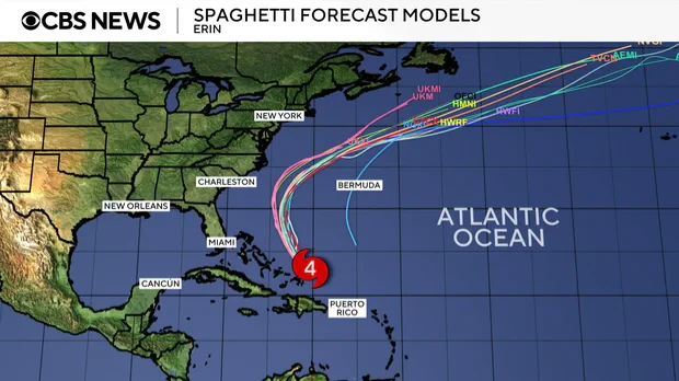
A "spaghetti map" of the forecast models shows the storm skirting the Caribbean islands and remaining well offshore of the U.S. East Coast as it moves north and curves back over the Atlantic.
 A "spaghetti map" shows forecast models of the path of Hurricane Erin as of Aug. 18, 2025. - CBS News
A high-pressure system in the Atlantic was expected to steer Erin away from the U.S. coast while a cold front was also forecast to push the hurricane offshore, CBS News Bay Area meteorologist Jessica Burch explained.
How will Hurricane Erin affect the U.S.?
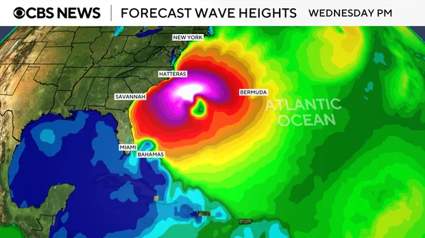
Erin is not forecast to hit the U.S. directly, but coastal areas along the Eastern Seaboard will feel its effects with dangerous high waves and rip currents over the next several days.
"These rough ocean conditions will likely cause life-threatening surf and rip currents," the National Hurricane Center warned.
 A map shows forecast wave heights along the U.S. East Coast from Hurricane Erin for Wednesday, Aug. 20, 2025. - CBS
North Carolina's Outer Banks, in particular, should monitor the progress of Erin, the hurricane center advised, noting that In addition to rip currents, "there is a risk of strong winds associated with the outer rainbands during the middle part of the week."
Gusty winds and flooding tides could wash out parts of the highway that connects the North Carolina Outer Banks by midweek, the National Weather Service said.
First hurricane of the Atlantic season
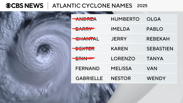
Erin formed as a tropical storm on Monday west of the island nation of Cabo Verde, a few hundred miles off Africa's western coast. It is the fifth named storm of the 2025 Atlantic hurricane season, which started in June and runs through November.
So far this year, Tropical Storm Chantal is the only one to have made landfall in the U.S., bringing deadly flooding to North Carolina in early July. In June, Barry made landfall as a tropical depression on Mexico's eastern coast.
Erin's increased strength comes as the Atlantic hurricane season approaches its peak in September. According to the hurricane center, most of the season's activity typically happens between mid-August and mid-October. In the eastern Pacific Ocean, hurricane season starts on May 15 with a peak in activity typically seen in late August.
 These are the names for the Atlantic cyclone names for 2025. - CBS
The U.S. National Oceanic and Atmospheric Administration, or NOAA, forecast an above-normal season for the Atlantic this year, expecting between 13 and 18 named storms.
Tropical storms have maximum sustained winds of at least 39 mph. Forecasters with NOAA anticipated that between five and nine of the storms this year could become hurricanes, which have sustained winds of at least 74 mph. Hurricanes are rated on a scale based on their wind speeds, ranging from Category 1, the weakest, to Category 5, the most severe rating.
NOAA forecasters predicted there could be between two and five major hurricanes in the Atlantic this season.
Nikki Nolan contributed to this report.
More Like This
August 18th, 2025
August 18th, 2025
August 18th, 2025
Top Headlines
August 18th, 2025


