Weather Blog: Chilly Temperatures Expected For Thanksgiving
Oklahoma Weather Forecast: Bookmark this page and refresh it often for the latest forecast and daily updates.Tuesday, November 26th 2024, 10:37 pm
TULSA, Okla. -
The upper airflow will bring some high, thin clouds across northern Oklahoma today, but mostly sunny conditions will persist for most of the day.
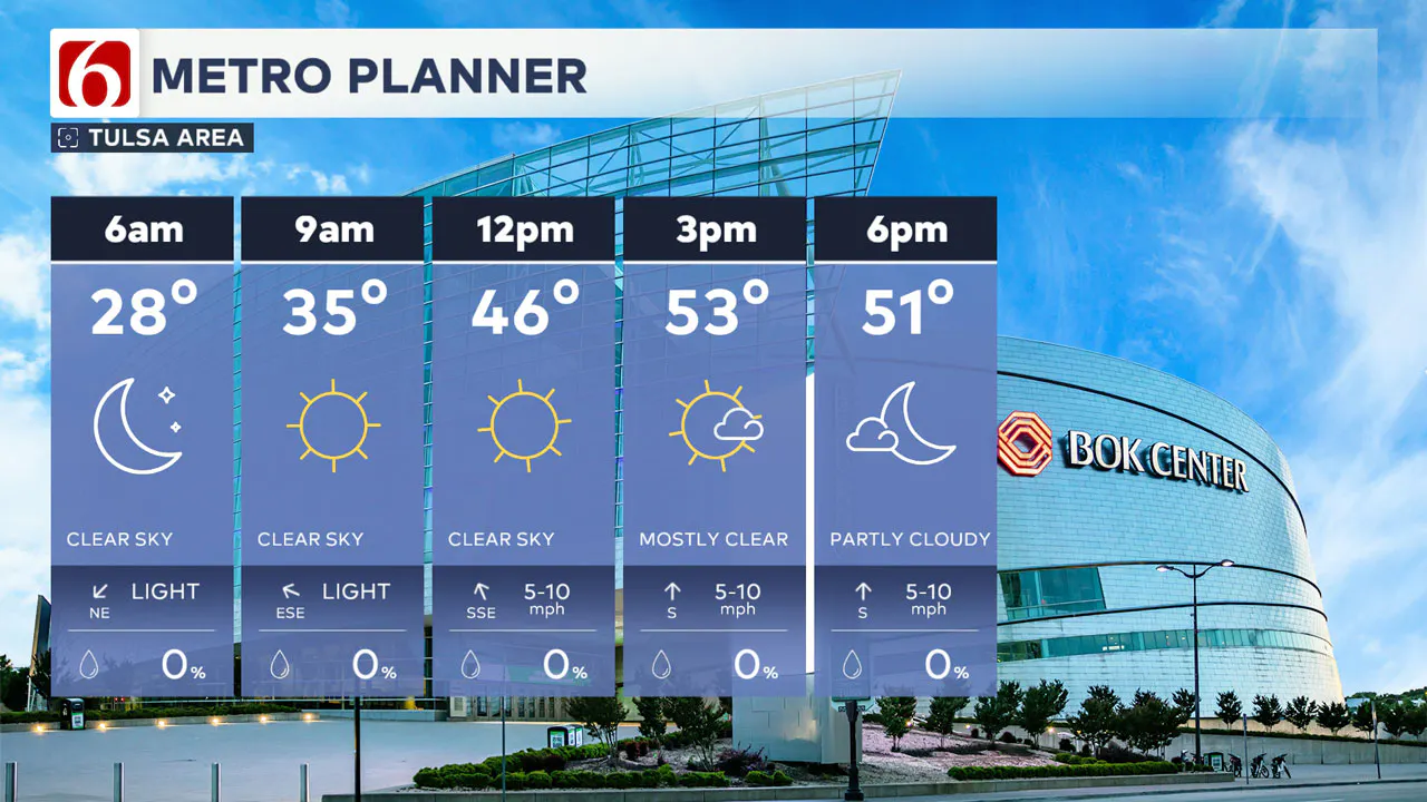
A surface ridge of high pressure will allow morning temperatures to drop into the 20s in northern Oklahoma and the lower 30s across the southern sections. Some patchy frost is likely early in the morning.
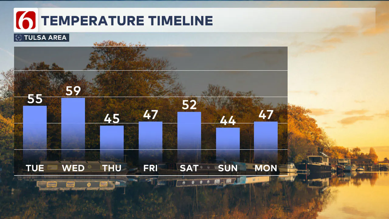
As the ridge moves south and east, south winds will return this afternoon at 7 to 10 mph, with daytime highs reaching the mid-50s in northern Oklahoma and near 60 across southeastern sections of the region.
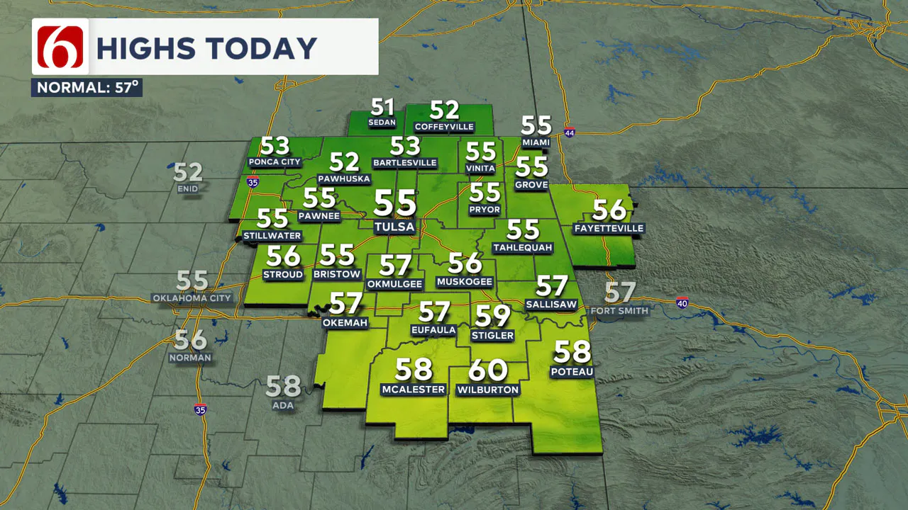
A fast and strong west-to-east flow will bring a disturbance nearby later this afternoon and tonight. As the pressure falls along and east of the Rockies, south winds will increase early tomorrow morning to 10 to 20 mph.
Wednesday morning lows will be in the mid-40s, with daytime highs in the northern sections reaching the upper 50s to near 60 before the front arrives at midday. Locations along and south of the I-40 corridor can expect highs in the upper 60s to near 70 by tomorrow afternoon before the front approaches.
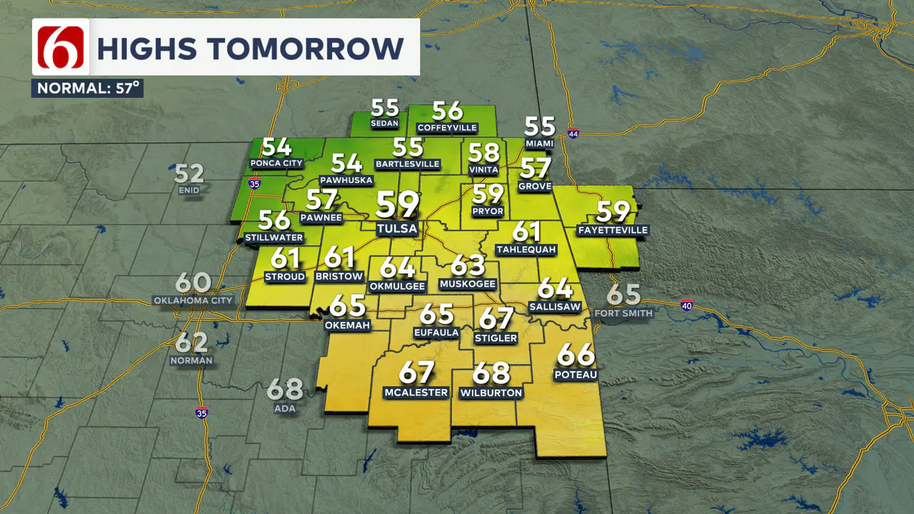
As the front moves across the area tomorrow afternoon, gusty north winds and falling temperatures are expected through the evening. There is potential for a narrow area of clouds tomorrow evening along and behind the boundary, which could produce some sprinkles or pockets of drizzle. This will remain a low-end chance across portions of the region late Wednesday evening into pre-dawn Thursday.
By early Thursday morning, the probability will exit the area as cool and dry weather returns.
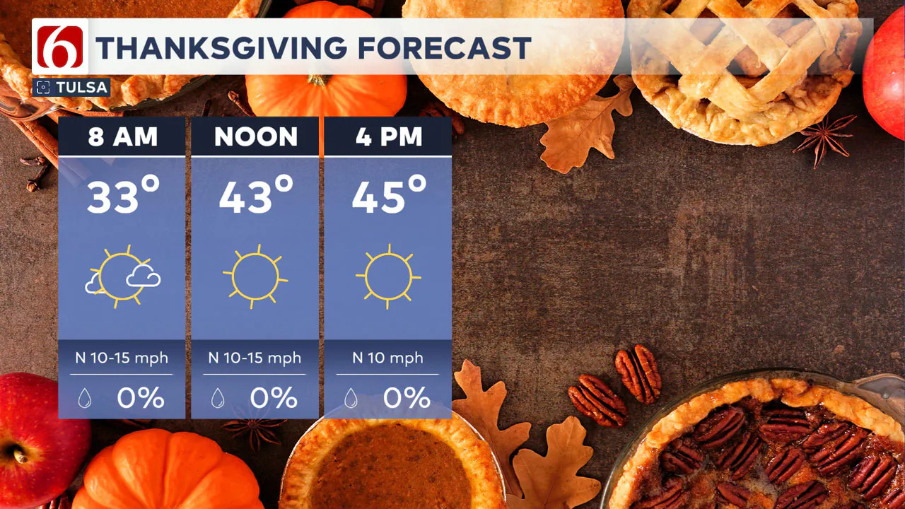
Thanksgiving morning temperatures will be in the mid-30s with daytime highs near 46 along with mostly sunny conditions and north winds at 10 to 15 mph.
A surface ridge of high pressure will allow temperatures to drop into the mid-20s early Friday morning. By Friday afternoon, we’ll continue with sunshine and highs in the upper 40s. Our next storm system will pass to the north this weekend but could bring another shot of cold weather to the region by Saturday afternoon and evening.
The exact trajectory of the weekend system remains questionable but is anticipated to stay north of our immediate area. Before it arrives, the south winds will return early Saturday morning with low temperatures near freezing and afternoon highs reaching the lower 50s.
As the front approaches, north winds will develop at midday with falling temperatures into the Saturday evening hours. There will remain a slight chance for some very light precipitation across southeastern Kansas and southwestern Missouri behind the front Saturday afternoon.
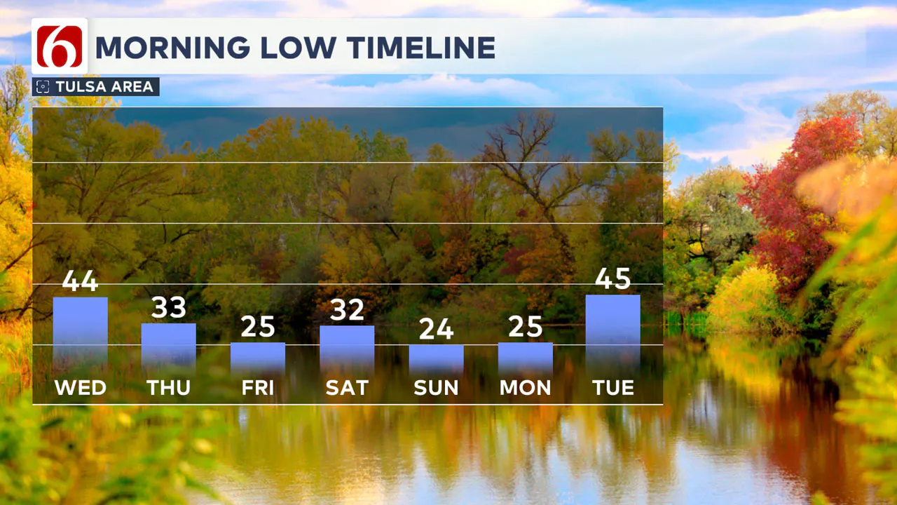
Cold weather will continue to filter into the area Saturday night, bringing Sunday morning temperatures into the mid-20s. Daytime highs on Sunday afternoon will be in the lower to mid-40s. Monday morning is anticipated to start in the mid-20s, with daytime highs approaching the mid-40s. Another system will be near or south of the area early next week.
Emergency Info: Outages Across Oklahoma:
Northeast Oklahoma has various power companies and electric cooperatives, many of which have overlapping areas of coverage. Below is a link to various outage maps.
Indian Electric Cooperative (IEC) Outage Map
Oklahoma Association of Electric Cooperatives Outage Map — (Note Several Smaller Co-ops Included)
The Alan Crone morning weather podcast link from Spotify:
https://open.spotify.com/episode/3u2fNr11hvXsWMnnnkcI40
The Alan Crone morning weather podcast link from Apple:
Follow the News On 6 Meteorologists on Facebook!

More Like This
November 26th, 2024
November 26th, 2024
November 26th, 2024
Top Headlines
November 26th, 2024
November 26th, 2024
November 26th, 2024


