Weather Blog: Below Normal Temperatures Return To Oklahoma
Oklahoma Weather Forecast: Bookmark this page and refresh it often for the latest forecast and daily updates.Wednesday, November 20th 2024, 6:09 am
TULSA, Okla. -
A series of mid-level waves will transit the central and northern plains but will have no direct impact on our weather regarding showers or storms.
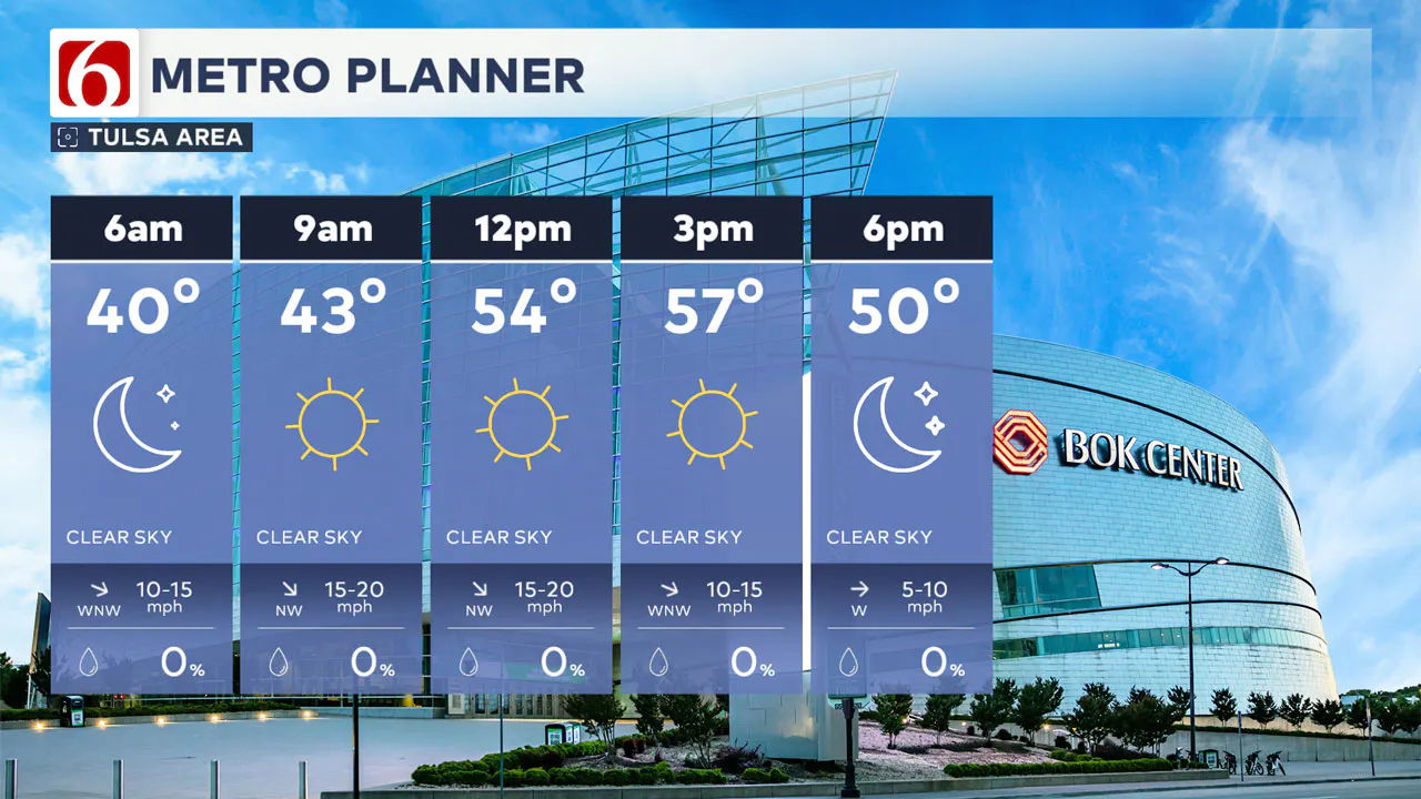
As these waves move east, a series of high-pressure ridges building through the central plains will effectively bring two weak fronts through the state. One occurred yesterday and is promoting the development of a surface ridge across part of Northwest Texas.
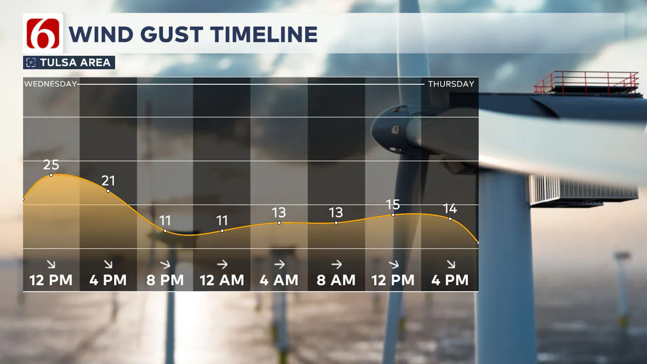
Most of our area will be on the backside of this ridge today bringing gusty northwest winds from 15 to 25 mph for the morning before decreasing throughout the afternoon.
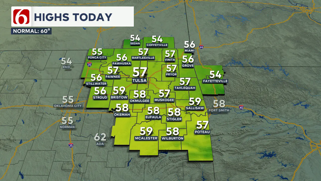
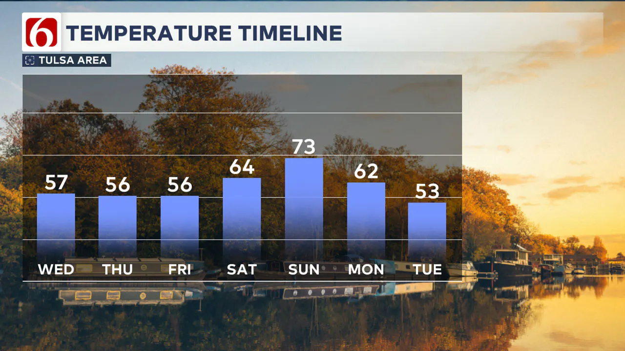
This will keep our highs cooler, with many locations remaining near or below normal. Afternoon highs will reach the mid to upper 50s north and lower 60s south.
By Thursday morning, temps will drop into the lower and mid 30s north where a few valleys will be near or below freezing. Thursday afternoon highs will reach the mid-50s with abundant sunshine and a lighter breeze.
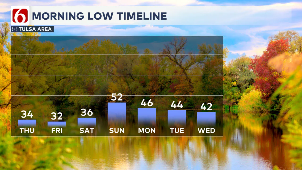
A stronger surface ridge will be nearby early Friday morning prompting the issuance of frost or freeze warnings for most of NE OK. Afternoon highs will stay in the lower to mid-50s.
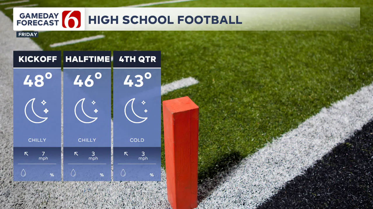
The 2nd round of the Oklahoma High School Football Playoffs continues Friday. Kickoff temps will be in the upper 40s and dropping into the lower 40s by the end of the game with light south winds.
This weekend, south winds return and bring a relatively warmer pattern with Saturday highs in the lower 60s and Sunday reaching the lower 70s.
Gusty south winds are likely Sunday before our next front arrives either Sunday night or early Monday morning with a minor cool-down into the 60s.
The extended data suggests a pattern change that should allow a surge of colder air arriving by Monday evening into Tuesday. We’ll be watching for the eventual outcome of a possible trough nearing the central plains early next week.
The main upper-level flow will be zonal (from the west to east) but a surge of colder air would be possible with this trough nearby.
This could promote the possibility of some precipitation, but the data remains too inconsistent to offer any valid solution for this period of the forecast. The initial outlook for the Thanksgiving Holiday supports below normal temps.
Mark Your Calendars
Here are a few events and updates to keep on your radar:
- Winter Forecast Special: Tune in Thursday night at 10 p.m. to catch our outlook for the season ahead.
- Jenks Lights On: Celebrate the kickoff to the holiday season this Thursday during our 5 and 6 p.m. shows.
- Coats for Kids: We’re continuing our efforts to collect coats for children in need, so don’t forget to donate!
Let’s enjoy this wild November ride together—rain, frost, and all. And remember, colder (and potentially snowier) days are just around the corner!
Emergency Info: Outages Across Oklahoma:
Northeast Oklahoma has various power companies and electric cooperatives, many of which have overlapping areas of coverage. Below is a link to various outage maps.
Indian Electric Cooperative (IEC) Outage Map
Oklahoma Association of Electric Cooperatives Outage Map — (Note Several Smaller Co-ops Included)
The Alan Crone morning weather podcast link from Spotify:
https://open.spotify.com/show/0dCHRWMFjs4fEPKLqTLjvy
The Alan Crone morning weather podcast link from Apple:
Follow the News On 6 Meteorologists on Facebook!

More Like This
November 20th, 2024
November 20th, 2024
November 20th, 2024
November 20th, 2024
Top Headlines
November 20th, 2024
November 20th, 2024
November 20th, 2024
November 20th, 2024


