Thunderstorms Move Through Green Country
Oklahoma Weather Forecast: Bookmark this page and refresh it often for the latest forecast and daily updates.Tuesday, May 21st 2024, 5:37 pm


TULSA, Okla. -
Severe thunderstorms moved through Green Country Tuesday evening, bringing large hail and heavy rains.

Severe storms caused roof damage and power poles down in Wainwright, according to Emergency Management Director Jeff Smith.
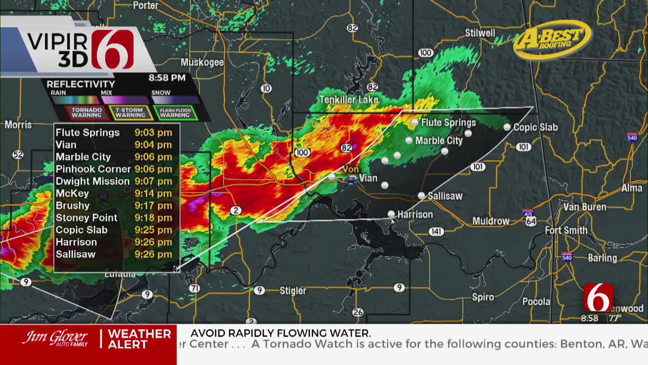
A tornado watch is active for parts of northeast Oklahoma until 10 p.m.
Severe Thunderstorm Warning
A severe thunderstorm warning has been issued for Haskell, Latimer, Le Flore, and Muskogee County until 10:45 p.m.
Tornado Watch in Oklahoma
A Tornado Watch has been issued for Adair, Cherokee, Craig, Delaware, Mayes, Muskogee, Nowata, Ottawa, Rogers, Tulsa, Wagoner, and Washington County until 10:00 pm. The watch was also issued in Labette and Montgomery County in Kansas as well as Benton and Washington County Arkansas.
A tornado warning was issued for Mayes and Rogers County, and later Delaware County, on Tuesday evening before expiring.
A series of storm chances will arrive later Tuesday night and persist through the latter half of the week into the weekend. The combination of abundant low-level moisture and strong upper-level forcing will create severe weather threats with most thunderstorm activity expected over the next few days.
What will the weather be like in Oklahoma on Tuesday, May 21?
Later Tuesday night into the overnight hours, additional storms are likely to form along both sides of the gradually descending front into Wednesday morning and midday near and south of Tulsa.
As the front moves southward, strong to severe thunderstorm activity will remain possible as the front sags into southern Oklahoma.
What are the storm chances in Oklahoma on Tuesday, May 21?
A dry line will approach from the west Tuesday afternoon and evening. A few storms will attempt to develop along and east of this feature later this afternoon and early evening. Stronger forcing will be positioned slightly northeast of the region and surface winds may be mostly from the southwest.

This may limit convergence along the dry line. Regardless, the potential for a few strong and severe storms will remain later Tuesday afternoon and evening, mostly near and east of the Tulsa metro. If storms develop, all modes will be possible.

A weak surface front will slowly move in later Tuesday night and effectively catch-up with the dry line, bringing cooler temperatures on Wednesday, yet storm chances will continue as the boundary stalls near or south of the Tulsa metro area.
What are the chances for severe weather in Oklahoma on Wednesday, May 22?
Another strong wave in the southwest flow brushes the area early Wednesday morning ( pre-dawn) and will fire-up additional storms near the front sagging slowly southward. Despite the early Wednesday morning hours, severe weather threats will remain.
Storms along and north of the boundary will have the tendency to be hailers, with any storms along or south of the front supporting all modes of severe weather.

After early to midday Wednesday, depending upon the exact number of storms, the front will more than likely be pushed even more southward along the Red River Valley.
Any additional storms Wednesday afternoon or evening should be confined to extreme southeastern OK and north TX. We’ll experience a modest cool-down Wednesday behind the front with highs in the lower to mid-70s north and lower 80s across southern Oklahoma.
Are there storm chances for Memorial Day weekend in Oklahoma?
This front will move northward again on Thursday as another upper wave approaches the state, bringing additional storm chances Thursday afternoon and evening into early Friday morning. Some severe weather threats will be possible.
There may be a brief lull in storm activity Friday afternoon and evening before chances increase again throughout the Memorial Day Holiday weekend due to a weak boundary positioned near the area and further upper-level support.
Storm chances are expected to persist through Monday, Memorial Day before the pattern becomes more from the northwest that may bring a few days of calmer weather early next week.
Outages Across Oklahoma:
Northeast Oklahoma has various power companies and electric co-operatives, many with overlapping areas of coverage. Below is a link to various outage maps.
Indian Electric Cooperative (IEC) Outage Map
Oklahoma Association of Electric Cooperatives Outage Map - (Note Several Smaller Co-ops Included)
The Alan Crone morning weather podcast link from Spotify:
https://open.spotify.com/episode/03KuCPYyb4hNFyC42Yo6Bt
The Alan Crone morning weather podcast link from Apple:
https://podcasts.apple.com/us/podcast/weather-out-the-door/id1499556141?i=1000656145416
Follow the News On 6 Meteorologists on Facebook!

Get The Daily Update!
Be among the first to get breaking news, weather, and general news updates from News on 6 delivered right to your inbox!
More Like This

May 21st, 2024

May 21st, 2024


Top Headlines

May 21st, 2024

May 21st, 2024
